You are here: Foswiki>Dmi Web>GovcomorgJubilee>CyberLands (20 Aug 2008, RichardRogers)Edit Attach
Cyberlands
Team
Anat Ben-David, Ganaele Langlois, Astrid Mager, Esther Weltevrede.Problem description
Platform biases:1. Google Maps does not list the Palestinian Territories.
2. Palestinian users of Facebook can't assign their country name as "Palestine"
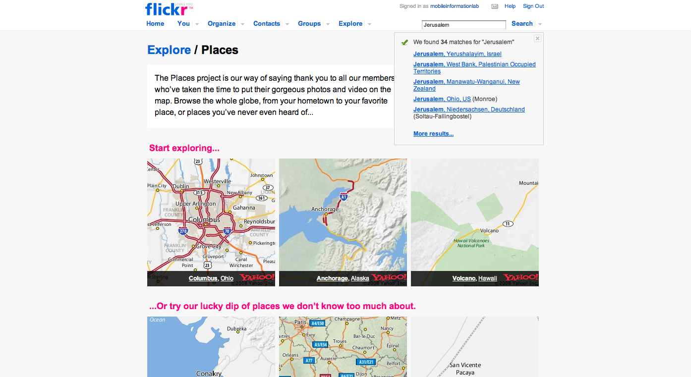
3. When searching for "Jerusalem" in Flickr, one can choose between two places: "Jerusalem, Israel", or "Jerusalem, West Bank, Palestinian Territories". Yet the latter redirect to the same photos under 'Jerusalem, Israel". It seems as though Web 2.0 platforms do not recognize the Palestinian Territories as a country, or even a (cyber)space, but rather as a "non-space". With the decentralization of content around the various Web 2.0 platforms, the struggle for establishing an online Palestinian state has to be fought over time and again for each new platform.
Question
What "place" is assigned to the Palestinian state on the Web, across the various Web 2.0 platforms? How do Palestinian users (and sympathizers) create user-generated content to circumvent the "non-creation" of Palestine on those platforms?Findings
Nomadic Citizenship: Palestinian Cyberland goes Web 2.0This study is a follow up of a previous study on Palestinian networks in cyberspace. In a previous study, we found fragmented hyperlink networks of Palestinian actors, as well as a rather weak infrastructure of the .ps domain as a representing Palestinian statehood on the Web. In this study, we resort to Web 2.0 applications, and to user-generated content, in order to examine how the Palestinian state is claimed on these new platforms.
As the Web becomes more decentralized, each Web 2.0 platform forms a close set of content, with its own set of rules, the question of Palestinian statehood on the Web needs to be examined across the different platforms. The more we study those platforms, however, the more we realize that the struggle after the recognition of an online Palestinian country has to be fought time and again for each Web 2.0 platform. That is, with the decentralization of the Web, the Palestinian Cyberland has to be established from the start in many places at the same time, not just under one solid, geographically oriented Web space under the .ps CcTld.
In the following, we portray our attempts to find a Palestinian state across Web 2.0 platforms. The more platforms we study, the more we come to realize that many Web 2.0 applications treat Palestine as a “non-land”. We then describe the nomadic experience of Palestinian user-generated content, to reclaim the grounds in each platform, time and again.
1. “Did Google Push Palestine into the Sea ?”
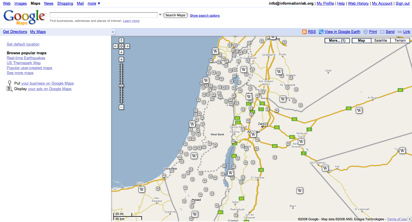
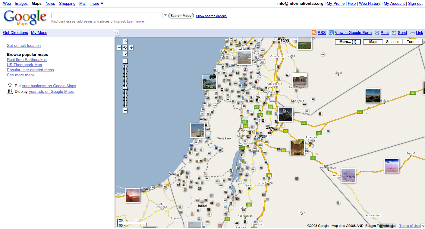
Our first observation starts with the attempt to locate the online Palestinian country in the various mapping software available on the Web. We start with Google Maps, where the Palestinian Territories do not have place markers. Geo-coded Wikipedia entries and photos, with exact longitude-latitude coordinates of places within the Palestinian Territories do not appear on Google Maps as well. In this map, the Palestinian Territories are defined by their “blankness” of data.
One blogger notes: “Denying the the whole Palestinian nation the right to be on the map can only be a gross error if one believes Google's slogan of "Do no Evil", but given Google's influence and presence on the Internet, this error can lead to the public believing that Palestine and its population of over 4 million does not exist, and that they have no right to existence.”[i]
Have other mapping platforms erased Palestine from the map?
Yahoo! maps, for example, the territories place marker is named “Occupied Palestinian Territories”, and terms such as “West Bank” and “Gaza City” lead to their pinpoint location on the map. Nevertheless, it is not possible to query for “Jerusalem”, within the West Bank, and the pinpointed location of the city is within the Israeli borders. Expedia’s way from avoiding having to define Palestine as a country goes as far as defining it a “Region in Asia”. A zoom in to this area reveals that the West Bank appears on the map with the word “disputed” added between brackets. On Mapquest’s drop-down menu one cannot choose for Palestine, or Palestinian Territories, but for “West Bank” and Gaza. Zooming in, the map shows only four Palestinian Cities, phonetically written according to their Hebrew spelling. Jerusalem is not listed within the West Bank.
Other mapping platforms show various levels of politically correctness: National Geographic’s MapMachine shows two “Jerusalem” on the map: One within Israeli border, the other in the West Bank; MSN’s livesearch maps return different placemarkers for the query of the Palestinian name of Jerusalem, “Al Quds”, which is east to the border, and for the query “Jerusalem”, which is pinpointed at the border itself; The mapping platform which seems to recognize Palestine the most is Multimap, which is based on MSN’s virtual earth mapping technology, which returns the following placemarker for the query Palestine: “Did you mean? Palestine, West Bank, Palestinian Territory (Occupied)”. Under this full definition, a zoom-in view of the map not only shows all Palestinian cities and villages in the West Bank (disputed), Wikipedia geo-coded entries appear on it as well. Jerusalem receives two names: West Jerusalem for the Israeli side, East Jerusalem for the Palestinian one.
Whilst users who sympathize with Palestine protest against Google Maps’ bias in different platforms such as blogs and groups on Facebook, others have decided to use Google’s geo mapping software itself to created the reverse image: Palestine Remembered, an NGO devoted for commemorating all Palestinian historical places, have created an extension for Google Earth, with a comprehensive geo-coded listing of as many as 5,600 Palestinian placemarkers. In this extension, Israeli cities and settlements are erased from the map.
2. Select Country Drop Down Forms: Standards, and editorial variations
In the process of signing-up for any Web 2.0 application, users are required to indicate their country, or location. An examination of the country drop-down lists of all popular Web 2.0 platforms shows, that it is often impossible to list “Palestine” as a country, let alone as a location, or a region. Whilst the ISO 3166-1 standard lists it under the name “Palestinian Territories, Occupied”, most of the drop-down forms present a various set of references, which indicate some extent of platform editorial decisions as to whether or not to enlist the Palestinian Territories, and which name to give it. Some platforms, such as MySpace, choose not to mention it at all; others resort to different variations such as separate entries for West Bank and Gaza, “Occupied Palestinian Territories”, “Palestinian Occupied Territories” and “Palestinian Territory”. Users put pressure on platforms to enlist Palestine as a country by grouping, signing petitions and warning that they will stop using those platforms if Palestine is not added as a country. Blogger accepted these requests and "Palestinian Territory" was added to the list. After long debating, and recurring enlisting and delisting, Facebook is currently the only pltaform that enlists "Palestine" under its full country name.
3. Facebook: claiming official statehood, reclaiming the ground by creating groups, applications, and networks.
We now move to specific social networking platforms to see how users fight over the Palestinian territories online. Let’s visit facebook first. As we have seen, users on Facebook can choose Palestine in the network list. However, this was not always the case. Palestine was once removed from the country code list. Later, it was re-listed again. The history of the fight over country code listings may be read from the Facebook group activities. When searching for Facebook groups dealing with the listing and subsequent de-listing and re-listing of Palestine as a country, we discovered a raging battle via Facebook groups over the claiming of Palestine as a „real“ Facebook place. There was an intense reaction against the de-listing of Palestine that translated as a flurry of Facebook groups petitioning and ordering the Facebook administrator to re-list Palestine. The tag cloud on the screen is a sample of the heated dabates that have been taking place on Facebook over the listing of Palestine as a country. The tag cloud is made up of a sample of groups on the issue and the size of the clouds represents the number of members in each group. Groups such as „Against Delisting Palestine from Facebook“ and „Official Petition to get Palesting Listed as a Country“ gathered respectively more than 16000 and 11000 members. Here are some illustrations of the multi-dimensionality of a controversy that is not only about territory, but also about the political symbolism associated with Palestine as expressed by group members. The group „Official Petition to have Palestine removed as a country on facebook“ argues:
By giving Palestine name recognition as a country, we are allowing a region that has not yet renounced terrorism, not yet recognized its neighbors right to live in peace, and not yet given up on its indoctrination that Jews are evil everything they ever wanted. If the Palestinians had a sense of humanity, at least one out there would speak out against violence towards the Jews yet no one has seen it yet. REMOVE PALESTINE FROM THE COUNTRY LIST! It never has been and the way they are going, will never be a recognized nation.
As a response, the group „Against delisting Palestine from Facebook“ created a petition against delisting Palestine from Facebook. Their argument goes as follows:
PALESTINE NETWORK WILL BE REMOVED FROM FACEBOOK IF THEY SEND ENOUGH MESSAGES. IT HAS BEEN DONE BEFORE, AND IT TOOK A LOT OF EFFORT TO BRING IT BACK. SO WE MUST SIGN THE PETITION PROVIDED BELOW AND DO THE STEPS REQUIRED FOR REPORTING. COME ON PEOPLE, MOVE!
The country code may thus be seen as one battlefield over the fight for Palestinian ground online.
Another way how users claim their Palestinian identity on Facebook is by creating applications. One of these applications is the Palestinian flag enabling users to send the Palestinian flag to friends.
The flag will then appear on the users’ profile signifying the claiming of a territory. Another application allows users to spread a „Palestinian lifestyle“ amongst their friends.
Finally, it is important to note that the decision to be part of the Palestinian network seems to be a definite decision, and that the choices offered by Facebook further reinforce the divide between Palestine and Israel, albeit at the platform level. One user described her experience like this:
„What I found interesting about joining the Palestine network is that, when I then tried to join the Israel network, it wasn't possible. Social identities on facebook seem to be static and mutually exclusive. I wonder how people choose between them?"
The controversy over the listing of Palestine as a country on Facebook is not simply an issue about having the possibility to choose a piece of information – it is also, and perhaps most importantly, a reenactement of the political and cultural struggles over the symbolic dimensions of Palestine as territory, identity, and non-space.
4. Flickr: Two Jerusalems Although Flickr relies on Yahoo! maps services for its geo-location of uploaded photos on the map, which include Palestinian cities and placemarkers, there are many ambiguities as to the precise location of Jerusalem as an Israeli or a Palestinian City. When the word “Jerusalem” is searched on Flicker’s location search, the user is asked to choose from two place markers: Jerusalem, Israel or Jerusalem, West Bank, Occupied Palestinian Territories. (file 1). After choosing the national affiliation of Jerusalem, the user is being redirected to the same set of geo-located photos for the “two Jerusalems”. (Files 2 and 3). A further zoom-in to the precise location of Jerusalem on those maps shows ambiguity in the location of the city in relation to the border. A query of “القدس” (Al Quds), the Palestinian name for Jerusalem, results in a map in which most of the geo-located photos are placed East to the border with Israel. (file 4). The returned set of photos is very different than the one returned for the search of Jerusalem in Flickr’s location search (the photos are essentially taken by Palestinians, or at least in the Palestinian parts of Jerusalem). A query of the English word “Jerusalem” for all geo-tagged maps, on the other hand, shows a distribution of geo-tagged photos across the two sides of the border, with a more Jewish-tinted set of photos. (file 5). Again, localized user generated data is used to claim the grounds of Palestine in the various Web platforms. Here, Jerusalem’s status as the Palestinian capital is being claimed by tagging it with its Palestinian Name in Arabic (file 6). Still, for the popular English language geo-tagged maps, the location of Jerusalem as a Palestinian city is ambiguous, and vague.
[i] Source: http://www.kawther.info/K20070606B.html
- Palestinian wiki:

- Palestinian wiki:

- Jerusalem Flickr:

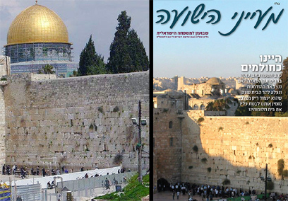
- Extreme Jewish Magazine Cover, Published Saturday,9/8/08 - Al Aqsa Mosque erased


- screenshot_palestine_debate_facebook.bmp: Facebook group debate on listing Palestine as a country
Presentation
Here is the final keynote presentation (without voiceover) as a zip file.- PalestinianCyberlandWeb2.0-final.zip: Palestinian Cyberland Keynote Presentation (no voiceover)
| I | Attachment | Action | Size | Date | Who | Comment |
|---|---|---|---|---|---|---|
| |
Jerusalem_flickr.png | manage | 449 K | 13 Aug 2008 - 14:45 | EstherWeltevrede | Jerusalem Flickr |
| |
Jerusalem_photos.png | manage | 289 K | 13 Aug 2008 - 14:44 | EstherWeltevrede | Palestinian wiki |
| |
Jerusalem_wiki.png | manage | 257 K | 13 Aug 2008 - 14:43 | EstherWeltevrede | Palestinian wiki |
| |
PalestinianCyberlandWeb2.0-final.zip | manage | 12 MB | 20 Aug 2008 - 14:56 | RichardRogers | Palestinian Cyberland Keynote Presentation (no voice-over) |
| |
al_aqsa_photoshoped.jpg | manage | 91 K | 14 Aug 2008 - 08:12 | AnatBenDavid | Al Aqsa Erased (source: http://www.ynet.co.il/articles/0,7340,L-3582275,00.html) |
| |
screenshot_palestine_debate_facebook.bmp | manage | 2 MB | 14 Aug 2008 - 15:04 | AnatBenDavid | Facebook group debate on listing Palestine as a country |
Edit | Attach | Print version | History: r10 < r9 < r8 < r7 | Backlinks | View wiki text | Edit wiki text | More topic actions
Topic revision: r10 - 20 Aug 2008, RichardRogers
 Copyright © by the contributing authors. All material on this collaboration platform is the property of the contributing authors.
 Ideas, requests, problems regarding Foswiki? Send feedback


